Trail  La Bresse - 2022-08-08_07h41m53_montagne-trekking-randonnee-lac-du-schiessrothied-depuis-le-hohneck - Photo

2022-08-08_07h41m53_montagne-trekking-randonnee-lac-du-schiessrothied-depuis-le-hohneck

 ACPL
ACPL

User

© OpenStreetMap contributors
Length
Length
8.8 km
Max alt
Max alt
1345 m
Uphill gradient
Uphill gradient
496 m
Km-Effort
Km-Effort  
15.5 km
Min alt
Min alt
922 m
Downhill gradient
Downhill gradient
496 m
Boucle
Boucle
Yes
Creation date :
2022-08-08 05:41:55.019
Updated on :
2022-08-08 05:41:56.446

(0 Reviews)


Scan this QR Code to open this trail in the SityTrail application

FREE GPS app for hiking

Logo SityTrail SityTrail

IGN / Geographical institutes

Download SityTrail from the App Store Download SityTrail from Google Play

Logo SityTrail SityTrail World

The world is yours!

Download SityTrail from the App Store Download SityTrail from Google Play Download SityTrail on Huawei AppGallery

About

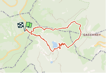
Trail of 8.8 km to be discovered at Grand Est, Vosges, La Bresse. This trail is proposed by ACPL.

Description

Départ au parking depuis la route des crêtes en bas du Hohneck
Lat/Lon : 48.03551/7.00748

1 / Prenez la route qui se situe a côté du restaurant “ Pied du Hogneck” pour monter au Hohneck. Puis tournez a droite pour prendre le sentier en direction du Lac de Schissrothied (balisage cercle bleu)
Lat/Lon : 48.03578/7.00798


2/ Continuez tout droit en direction de la vallée de la Wormsa, Lac du Schissrothied en suivant le balisage Triangle bleu
Lat/Lon : 48.03479/7.01079

3/ Continuez sur le sentier vers la gauche
Lat/Lon : 48.03441/7.01138

4/ Tournez a droite et suivez le triangle bleu
Lat/Lon : 48.03395/7.01601

5/ Lac du Schissrothied
Lat/Lon : 48.0287/7.02493

6/ Longer le lac du Schissrothied et prenez le GR 5 en direction du Hohneck pour atteindre l’auberge du Schissrothied (balisage rectangle rouge)
Lat/Lon : 48.02857/7.02519

7/ Continuez tout droit en direction de Schiessroth et Gashney GR5 en suivant le rectangle rouge et bleu
Lat/Lon : 48.02934/7.02704

8/ Puis tournez a gauche en direction du Schissroth GR5 (balisage rectangle rouge)
Lat/Lon : 48.02869/7.02799

9/ Une fois avoir passé l’auberge Schissrothied et la route, prenez le sentier en direction du Schallern Rothried en suivant le triangle bleu
Lat/Lon : 48.02944/7.03327

10/ Tournez a gauche et suivez le triangle bleu
Lat/Lon : 48.0364/7.03969

11/ Bifurquez vers la gauche en direction du Hohneck. Suivez le balisage rectangle rouge.
Lat/Lon : 48.03642/7.02572

12/ Source pour se ravitailler en eau
Lat/Lon : 48.03655/7.01952

13/ Vue panoramique du Hohneck
Lat/Lon : 48.03711/7.01675

14/ Arrivée au parking du pied du Hohneck
Lat/Lon : 48.03592/7.00828

Elevation profile

Positioning

Country:
France
Region :
Grand Est
Department/Province :
Vosges
Municipality :
La Bresse
Location:
Unknown
Start:(UTM)
351472 ; 5322168 (32U) N.

Trails nearby

Trail Walking La Bresse - 2023-04-16 Marche Abri Lac de Blanchemer vers Lac de Lispach - Photo
Walking
GUIDE
holtzv

Walking

Very difficult
(1)
La Bresse, Grand Est, Vosges, France
23 km | 36 km-effort
8h 4min
No
Trail Walking Le Valtin - Les Rochers des Hirschsteine - Lac Vert - Photo
Walking
GUIDE
Michel1963

Walking

Difficult
(2)
Le Valtin, Grand Est, Vosges, France
14.4 km | 22 km-effort
5h 2min
Yes
Trail Walking Le Valtin - Le Sentier des Roches - Photo
Walking
GUIDE
Michel1963

Walking

Difficult
(2)
Le Valtin, Grand Est, Vosges, France
20 km | 34 km-effort
7h 43min
Yes
Trail Walking La Bresse - Lac de Lispach et sentier Dielaine  - Photo
Walking
zazie

Walking

Medium
(1)
La Bresse, Grand Est, Vosges, France
9.7 km | 14.9 km-effort
2h 30min
Yes
Trail Walking Stosswihr - Tour du belvedere avec le passage sur les crêtes  - Photo
Walking
ocepee

Walking

Very easy
(2)
Stosswihr, Grand Est, Haut-Rhin, France
8.5 km | 0 m-effort
2h 28min
Yes
Trail Walking La Bresse - Kastelberg des pierres, des lacs, des panoramas magnifiques  - Photo
Walking
Alfredy

Walking

Difficult
(1)
La Bresse, Grand Est, Vosges, France
15.1 km | 26 km-effort
6h 11min
Yes
Trail Walking La Bresse - Les 5 lacs autour du Hohneck - Photo
Walking
tiene

Walking

Very difficult
(1)
La Bresse, Grand Est, Vosges, France
21 km | 36 km-effort
7h 21min
Yes
Trail Walking Wildenstein - Col du Bramont - Machey - Blanchemer - Photo
Walking
VacheKiri67

Walking

Medium
(1)
Wildenstein, Grand Est, Haut-Rhin, France
15.3 km | 22 km-effort
4h 27min
Yes
Trail Walking Le Valtin - Les Hirschsteine - Photo
Walking
VacheKiri67

Walking

Difficult
(1)
Le Valtin, Grand Est, Vosges, France
16.1 km | 25 km-effort
6h 28min
Yes


Close
My subscriptions